Heat Advisory
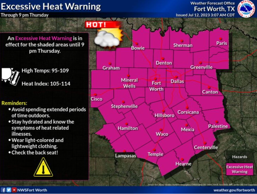
URGENT - WEATHER MESSAGE
National Weather Service Fort Worth TX
222 PM CDT Thu Jul 13 2023

Montague-Cooke-Grayson-Fannin-Lamar-Young-Jack-Wise-Denton-Collin-Hunt-Delta-Hopkins-Stephens-Palo Pinto-Parker-Tarrant-Dallas-Rockwall-Kaufman-Van Zandt-Rains-Eastland-Erath-Hood-Somervell-Johnson-Ellis-Henderson-Comanche-Mills-Hamilton-Bosque-Hill-Navarro-Freestone-Anderson-Lampasas-Coryell-Bell-McLennan-Falls-Limestone-Leon-Milam-Robertson-Including the cities of Bowie, Nocona, Gainesville, Sherman,Denison, Bonham, Paris, Graham, Olney, Jacksboro, Decatur, Bridgeport, Carrollton, Denton, Lewisville, Flower Mound, Plano, McKinney, Allen, Frisco, Greenville, Commerce, Cooper, Sulphur Springs, Breckenridge, Mineral Wells, Weatherford, Briar, Fort Worth, Arlington, Dallas, Rockwall, Heath, Terrell, Kaufman, Forney, Canton, Grand Saline, Wills Point, Van, Edgewood, Emory, East Tawakoni, Point, Cisco, Eastland, Ranger, Gorman, Stephenville, Dublin, Granbury, Oak Trail Shores, Glen Rose, Cleburne, Burleson, Waxahachie, Ennis, Midlothian, Athens, Gun Barrel City, Comanche, De Leon, Goldthwaite, Hamilton, Hico, Clifton, Meridian, Valley Mills, Hillsboro, Corsicana, Teague, Fairfield, Wortham, Palestine, Lampasas, Copperas Cove, Gatesville, Killeen, Temple, Fort Cavazos, Waco, Marlin, Mexia, Groesbeck, Buffalo, Centerville, Jewett, Normangee, Oakwood, Cameron, Rockdale, Hearne, Franklin, and Calvert

...EXCESSIVE HEAT WARNING REMAINS IN EFFECT UNTIL 9 PM CDT THURSDAY EVENING...
...HEAT ADVISORY IN EFFECT FROM 9 PM THURSDAY EVENING TO 9 PM CDT FRIDAY...

* WHAT...For the Excessive Heat Warning, dangerously hot
  conditions with heat index values up to 115. For the Heat
  Advisory, heat index values up to 110 expected.

* WHERE...All of North and Central Texas.

* WHEN...For the Excessive Heat Warning, until 9 PM CDT this
  evening. For the Heat Advisory, from 9 PM this evening to 9 PM
  CDT Friday.

* IMPACTS...Extreme heat and humidity will significantly increase
  the potential for heat related illnesses, particularly for those
  working or participating in outdoor activities.

PRECAUTIONARY/PREPAREDNESS ACTIONS...

Drink plenty of fluids, stay in an air-conditioned room, stay out
of the sun, and check up on relatives and neighbors. Young
children and pets should never be left unattended in vehicles
under any circumstances.

Take extra precautions if you work or spend time outside. When
possible reschedule strenuous activities to early morning or
evening. Know the signs and symptoms of heat exhaustion and heat
stroke. Wear lightweight and loose fitting clothing when
possible. To reduce risk during outdoor work, the Occupational
Safety and Health Administration recommends scheduling frequent
rest breaks in shaded or air conditioned environments. Anyone
overcome by heat should be moved to a cool and shaded location.
Heat stroke is an emergency! Call 9 1 1.
Listen to WBAP/KLIF report:
Thursday
A slight chance of showers and thunderstorms between 7am and 10am. Sunny and hot, with a high near 104. Heat index values as high as 114. South wind 10 to 15 mph, with gusts as high as 20 mph. Chance of precipitation is 20%.
Thursday Night
Mostly clear, with a low around 81. South wind 10 to 15 mph, with gusts as high as 25 mph.
Friday
Mostly sunny and hot, with a high near 103. Heat index values as high as 110. South southwest wind around 10 mph.
Friday Night
Partly cloudy, with a low around 81. South wind 10 to 15 mph, with gusts as high as 25 mph.
Saturday
Mostly sunny and hot, with a high near 102. South southwest wind around 10 mph.
Saturday Night
A 20 percent chance of showers and thunderstorms after 1am. Partly cloudy, with a low around 80. South southeast wind 10 to 15 mph, with gusts as high as 20 mph.
Sunday
A 20 percent chance of showers and thunderstorms. Partly sunny, with a high near 97. South southeast wind around 10 mph.
Sunday Night
Partly cloudy, with a low around 79. Southeast wind around 10 mph.
Monday
Sunny and hot, with a high near 103.
(The Weather Channel)