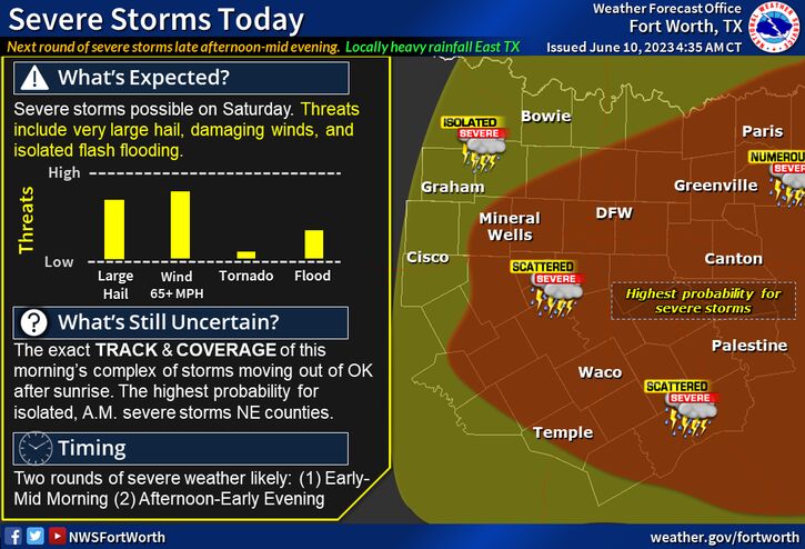
(WBAP/KLIF) — Severe thunderstorms are possible across North and Central Texas on today. A complex of strong to severe storms will likely impact eastern portions North Texas this morning, before re-developing near and south of I-20 around mid afternoon. The second round will likely be the more impactful round of storms with primary hazards that include large to very large hail, damaging winds to 70 mph+, frequent lightning strikes, and localized heavy rainfall with isolated instances of flooding or flash flooding across the East. Continue to check back frequently for forecast updates and keep a close eye on the sky, especially if you have outdoor plans!
TXZ091>095-100>107-115>123-129>135-141>148-156>162-174-175-110830-
Montague-Cooke-Grayson-Fannin-Lamar-Young-Jack-Wise-Denton-Collin-
Hunt-Delta-Hopkins-Stephens-Palo Pinto-Parker-Tarrant-Dallas-
Rockwall-Kaufman-Van Zandt-Rains-Eastland-Erath-Hood-Somervell-
Johnson-Ellis-Henderson-Comanche-Mills-Hamilton-Bosque-Hill-Navarro-
Freestone-Anderson-Lampasas-Coryell-Bell-McLennan-Falls-Limestone-
Leon-Milam-Robertson-
Sat Jun 10 2023
This Hazardous Weather Outlook is for North and Central Texas.
.DAY ONE…Today and Tonight.
A complex of storms may cross the Red River early this morning with
additional thunderstorm chances this afternoon and evening across
most of North and Central Texas. Severe weather is possible with the
primary threats being large hail and damaging wind gusts.
(Copyright 2023 WBAP/KLIF Newsroom News. All rights reserved.)