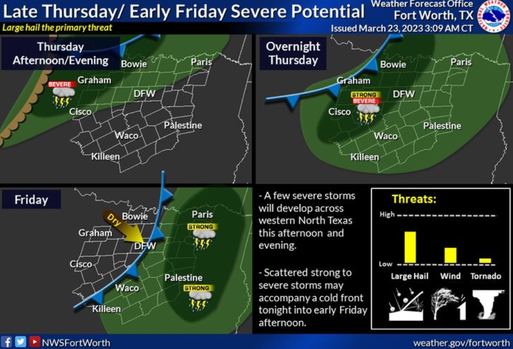
Severe thunderstorms may develop late Thursday across western North Texas with more widespread showers and thunderstorms accompanying a cold front moving through the area later Thursday night into Friday. Potential hazards include large hail, damaging winds, and a couple tornadoes primarily north of I-20/30.
Today
Cloudy, then gradually becoming mostly sunny, with a high near 82. South wind 15 to 20 mph, with gusts as high as 30 mph.
Tonight
A slight chance of showers and thunderstorms between 1am and 4am, then showers likely and possibly a thunderstorm after 4am. Mostly cloudy, with a low around 66. South wind 15 to 20 mph, with gusts as high as 30 mph. Chance of precipitation is 60%. New rainfall amounts of less than a tenth of an inch, except higher amounts possible in thunderstorms.
Friday
Showers likely and possibly a thunderstorm before 1pm. Cloudy through mid morning, then gradual clearing, with a high near 79. South southwest wind around 15 mph, with gusts as high as 25 mph. Chance of precipitation is 60%. New rainfall amounts between a tenth and quarter of an inch, except higher amounts possible in thunderstorms.
Friday Night
Mostly clear, with a low around 54. West southwest wind 10 to 15 mph, with gusts as high as 20 mph.
Saturday
Sunny, with a high near 75. West wind 10 to 15 mph, with gusts as high as 25 mph.
Saturday Night
Mostly clear, with a low around 48. West wind 5 to 10 mph becoming east southeast after midnight.
Sunday
Sunny, with a high near 77. East southeast wind 5 to 15 mph becoming south in the afternoon. Winds could gust as high as 20 mph.