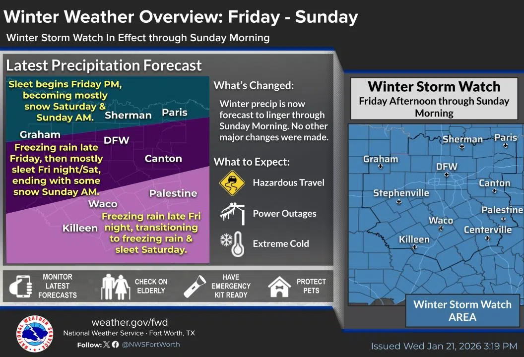

WINTER STORM WATCH REMAINS IN EFFECT FROM FRIDAY AFTERNOON THROUGH SUNDAY MORNING… * WHAT…Heavy mixed precipitation possible. Total snow and sleet accumulations between 1 and 5 inches. Ice accumulations between a quarter of an inch and one half of an inch possible, with isolated ice accumulations up to three quarters of an inch. * WHERE…North Central and Northeast Texas. * WHEN…From Friday afternoon through Sunday morning. * IMPACTS…The strong winds and weight of snow on tree limbs may down power lines and could cause sporadic power outages. Significant ice accumulation on power lines and tree limbs may cause widespread and long-lasting power outages. Expect power outages and tree damage due to the ice. Travel could be impossible. PRECAUTIONARY/PREPAREDNESS ACTIONS… Monitor the latest forecasts for updates on this situation. Consider delaying all travel. If travel is absolutely necessary, drive with extreme caution. Take a winter storm kit along with you, including such items as tire chains, booster cables, flashlight, shovel, blankets and extra clothing. Also take water, a first aid kit, and anything else that would help you survive in case you become stranded.
EXTREME COLD WATCH REMAINS IN EFFECT FROM SATURDAY EVENING THROUGH MONDAY MORNING… * WHAT…Dangerously cold wind chills as low as 10 below zero possible. * WHERE…All of North and Central Texas. * WHEN…From Saturday evening through Monday morning. * IMPACTS…The dangerously cold wind chills as low as 10 below zero could result in hypothermia or frostbite on exposed skin if precautions are not taken. PRECAUTIONARY/PREPAREDNESS ACTIONS… Dress in layers including a hat, face mask, and gloves if you must go outside. Make frequent checks on vulnerable family, friends, and neighbors. Ensure portable heaters are used correctly. Do not use generators or grills inside.
Today
Partly sunny, with a high near 59. East wind around 5 mph.
Tonight
Mostly cloudy, with a low around 42. East wind around 5 mph.
Friday
Showers likely, mainly after noon. Cloudy, with a temperature rising to near 48 by 10am, then falling to around 41 during the remainder of the day. East northeast wind 5 to 15 mph, with gusts as high as 20 mph. Chance of precipitation is 70%. New precipitation amounts between a quarter and half of an inch possible.
Friday Night
Rain showers, possibly mixed with sleet before midnight, then rain showers, freezing rain, and sleet between midnight and 3am, then freezing rain and sleet after 3am. Low around 26. Northeast wind 10 to 15 mph, with gusts as high as 20 mph. Chance of precipitation is 100%. New ice accumulation of less than a 0.1 of an inch possible. New sleet accumulation of less than a half inch possible.
Saturday
Freezing rain and sleet. The sleet could be heavy at times. Temperature falling to around 24 by 5pm. North northeast wind 10 to 15 mph, with gusts as high as 25 mph. Chance of precipitation is 100%.
Saturday Night
Freezing rain and sleet before midnight, then freezing rain and sleet likely, possibly mixed with snow showers between midnight and 3am, then snow showers and sleet likely after 3am. Low around 14. North northwest wind around 10 mph, with gusts as high as 20 mph. Chance of precipitation is 90%.
Sunday
A chance of snow showers and sleet before noon. Mostly cloudy and cold, with a high near 23. North northwest wind 10 to 15 mph, with gusts as high as 25 mph. Chance of precipitation is 30%.
Sunday Night
Partly cloudy, with a low around 8. North northwest wind 5 to 10 mph becoming light northwest after midnight.
Monday
Sunny, with a high near 33. Calm wind becoming west southwest around 5 mph.
Monday Night
Mostly clear, with a low around 16.
Tuesday
Mostly sunny, with a high near 41.
Tuesday Night
Partly cloudy, with a low around 27.
Wednesday
Mostly sunny, with a high near 44.