Widespread icing on bridges and overpasses as well as surface streets is expected with travel significantly impacted . There is a low chance of some downed power-lines and tree damage due to ice.
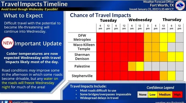
Tuesday
Freezing rain and sleet before 3pm, then a chance of sleet. High near 28. North wind around 15 mph, with gusts as high as 20 mph. Chance of precipitation is 80%. New ice accumulation of 0.1 to 0.2 of an inch possible. New sleet accumulation of less than a half inch possible.
Tuesday Night
A chance of freezing rain and sleet before 9pm, then freezing rain likely. Cloudy, with a low around 28. North wind around 10 mph, with gusts as high as 20 mph. Chance of precipitation is 70%. New ice accumulation of 0.1 to 0.3 of an inch possible. Little or no sleet accumulation expected.
Wednesday
Freezing rain. High near 32. North wind 5 to 10 mph. Chance of precipitation is 90%.
Wednesday Night
Showers. Temperature rising to around 35 by 8pm. North wind 5 to 10 mph. Chance of precipitation is 90%.
Thursday
A 40 percent chance of showers. Cloudy, with a high near 49. North northwest wind 10 to 15 mph, with gusts as high as 20 mph.
Thursday Night
A 30 percent chance of showers before midnight. Mostly clear, with a low around 33. North northwest wind 10 to 15 mph, with gusts as high as 20 mph.
Friday
Sunny, with a high near 52. North northwest wind 5 to 10 mph becoming east southeast in the afternoon.